Prelims: Fossils
Mains: General Studies Paper-3, Science and Technology- development and applications and its impact on everyday life. |
Why in the NEWS?
- An important scientific discovery has been made in Pakur district of Jharkhand.
Key Points:
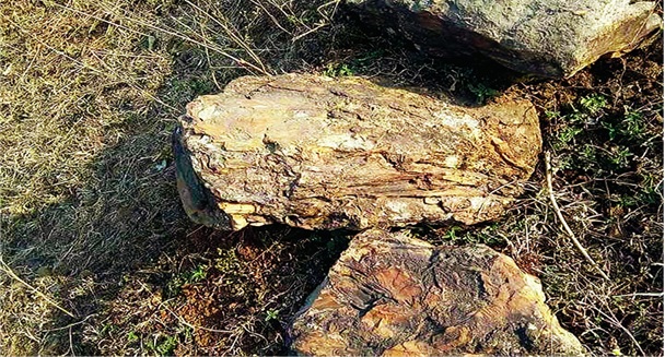
- Geologists and forest officials have unearthed a rare and well-preserved fossil in the Rajmahal Hills located near Barmasia village.
- Geologist Ranjit Singh, who led the discovery, has claimed that the fossil is about 100-145 million years old.
- The plant, which is believed to belong to the Cretaceous period, has been fossilised in its true form.
- Geologists believe that extensive exploration in this region can also lead to the possibility of finding dinosaur fossils.
- In addition, this exploration can help scientists gain a better understanding of geological activities and climate changes.
What will you read next in this topic?
- Historical Importance of Rajmahal Hills
- Rajmahal Fossil Park
- Geological Survey of India (GSI):
Historical Importance of Rajmahal Hills
- The Rajmahal Hills are formed due to at least 16 to 18 lava flows.
- Scientists believe that these hills had several volcanic eruptions in the past, which affected the climate and ecosystem here.
- The abundance of fossils in this area indicates that vast vegetation was once found here.
- This area was part of the Gondwana landmass, and the structure here makes it clear that it was once a dense forest area.
- The fossils found in these hills provide evidence of vegetation and volcanic activities.
- In ancient times, this area must have been the center of various biodiversity, which got extinct due to geological processes over time.
- According to facts recorded in history, this area was used for military strategy during the 16th century during the reign of Mughal Emperor Akbar.
- These hills were important from a strategic point of view and trade routes also passed through here.
- The region remained important even during British rule, as it was rich in coal mines and other mineral resources.
Rajmahal Fossil Park
- Located in the Rajmahal Hills of Jharkhand, Rajmahal Fossil Park is one of the geological heritages of India.
- The fossils found here offer a glimpse of the ancient ecosystem and climate history of the Indian subcontinent.
- There are plans to develop this area as an important center for geo-tourism and scientific research at the global level.
Major fossils found in Fossil Park
- Plant fossils – Remains of extinct flora like gymnosperms, ferns, and cycads are found here.
- Tree fossils – Fossils of trees up to 20 feet tall have been discovered, indicating that this area was once covered with vast dense forests.
- Possible dinosaur fossils – Scientists estimate that if extensive research is done in this area, remains of dinosaurs or other ancient creatures can also be found.
Conservation and development plans
- It is proposed to develop the Rajmahal Fossil Park as a UNESCO Global Geo-park to make it an international level geo-tourism and research centre. Under this:
- A geo-tourism centre will be set up to provide information to tourists and researchers about the fossils and the geological history of the Rajmahal Hills.
- A scientific research centre and a Centre of Excellence will be set up where geologists and students will be able to carry out research.
- A site conservation programme will be implemented to conserve the fossils so that these ancient remains can be saved from damage.
Geological Survey of India (GSI):
- Geological Survey of India (GSI) is the premier geological institution of India, which conducts research and surveys related to the country's geology, mineral resources, environmental geology, seismology and geo-tourism.
- It works under the Ministry of Mines, Government of India and was established in 1851 by the British Government.
Main objectives of GSI
- Geological Survey and Mapping - Studying the geological structure of India and preparing maps.
- Exploration of Mineral Resources - To find deposits of various precious metals, coal, iron ore, bauxite, and other minerals.
- Seismology and Disaster Management - Monitoring and analysis of earthquakes, landslides, and other geological disasters.
- Hydrology and Environmental Studies - Study of water resources and geological activities related to environmental protection.
- Bio-geological Research - Discovery of fossils and study of the geological history of India through them.
Historical background of GSI
- GSI was established in 1851 under the leadership of Thomas Oldham.
- Initially its main objective was to explore coal and other mineral resources, but later its scope expanded to other areas of geology.
- After independence, GSI was empowered for industrial development and structural geological studies of India.
Major activities of GSI
- Mineral exploration - Surveying the mineral resources present in the country and locating potential mines.
- Geological mapping - Preparing geological maps of the whole of India, which are useful for construction, mining, and environmental research.
- Monitoring geo-disasters - Studying earthquakes, landslides, coastal erosion and other geological disasters and suggesting measures to deal with them.
- Hydrology and water resources management - Studying groundwater level and quality of water sources.
- Geo-tourism and palaeontology - Discovery and preservation of fossils, which can provide information about the geological history of India.
Important Projects and Initiatives
- National Geological Mapping Programme (NGMP) – Project to prepare detailed geological maps in all the states of India.
- Mineral Exploration Projects – Exploration and evaluation of mineral deposits in different parts of the country.
- Bio-geological Studies – Geological research in areas with ancient fossils and deposits such as Rajmahal Hills.
- Geo-tourism Development – Scheme to develop important geological sites of India as tourist destinations.
Contributions and Importance of GSI
- GSI has played a vital role in the exploration of the mineral resources of the country, leading to the identification of coal, iron ore, bauxite, gold, and other minerals.
- Its seismic studies and mapping have helped in identifying earthquake prone areas of India.
- Studies of water resources have helped in maintaining groundwater levels and water conservation efforts.
- GSI is running conservation and awareness programmes at several important sites to promote geo-tourism.
|
Q. Where is the headquarters of Geological Survey of India (GSI) located?
(a) Mumbai
(b) New Delhi
(c) Kolkata
(d) Chennai
|


 Contact Us
  New Batch : 9555124124/ 7428085757
  Tech Support : 9555124124/ 7428085757