
|
Syllabus: Prelims GS Paper I : Current Events of National and International Importance. Mains GS Paper II : India and its Neighbourhood-Relations; Bilateral, Regional and Global Groupings and Agreements involving India and/or affecting India’s interests. |
Context
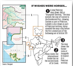
Pakistan unveiled a new map that illegally shows some parts of India, within its territory.
The Pakistan government has issued a map after one year of abrogation of Article 370 and 35A that shows the entirety of Jammu and Kashmir and the former Gujarati princely state of Junagadh as Pakistani territory. Such maps were common in the 1950s. Over time, Junagadh was largely dropped, but Survey of Pakistan maps have shown the border running south of Jammu.
In Detail
Pakistan has spent the past year trying to argue the issue. Initially, it turned to the international community to get some support. When that failed, it resumed shelling across the Line of Control and supporting terrorism. That Mr Khan’s government has now been reduced to printing pieces of coloured paper should be seen as further evidence that Pakistan has been reduced to a cipher as far as Kashmir is concerned.
However, it does not seem that there has been any change in the territorial outlines of the map, compared to the previous official version.
The Survey of Pakistan’s webpage does not have a copy of the official map right now. But, the archived snapshot of the website showed that the website did have a separate section described as “Pakistan maps”, which has since been removed.
This section previously had links to two maps – an “official map” and another map “with border lengths”.
Impact of the Move
Pakistan's position on its claim on Indian territory has shifted, badly effect the peace talks between India and Pakistan. The claim on the territories of Junagarh and Manavadar has weakened the overall image of Pakistan. Manavadar, a princely territory, joined India on February 15, 1948 and Indian troops marched into Junagarh in September that year incorporating it into Indian territory. Though it has no global support but it may be used by Pakistan to provide legal cover for some of Islamabad’s territorial ambitions, especially in Kashmir and Sir Creek.
| Sir Creek is a collection of water bodies that extend from the Arabian Sea deep inside the territory of Kutch and is rich in biodiversity and mangrove forests. India’s position on Sir Creek is based on the Kutch arbitration case of 1966-69. The new map can be used to reassert Pakistan’s claims regarding the Rann which it had lost in the arbitration conducted in Geneva. India’s position regarding Sir Creek is based on the fact that the arbitration had granted the entire Rann and its marshy areas to India while leaving the solid land across the Rann to Pakistan. |
India's External Boundaries
On 15 Aug 1947, when India gained freedom, its map was still unclear. Several princely states had yet to decide how and on what terms they would join the Indian Union. The Indian army played a key role in annexing Hyderabad in September 1948 but integration of independent territories through other means also led to changes in its map.
Junagadh in Gujarat joined India through a plebiscite in February 1948. The north-eastern states of Manipur and Tripura joined India following merger agreements in 1949.
The first major crack in India’s territory appeared in January 1949 when the United Nations intervened in the Indo-Pak war. India retained two-thirds of the Kashmir valley while Pakistan was granted control over Gilgit-Baltistan and Pakistan-occupied-Kashmir (PoK). In 1963, Pakistan would hand over a part of the territory it had acquired in the Ladakh region - the Trans Karakoram tract - to China.
In 1984, the Indian Army seized control over the Siachen glacier as part of Operation Meghdoot. While Siachen was considered part of India in its official documents, Pakistan had begun showing it as part of its territory in its official maps since the 1960s, following up with travel expeditions in the 1970s.
Since then, the Line of Control (LoC) between India and Pakistan has remained largely unchanged. Although Pakistani infiltrators did manage to secure a toe-hold in Kargil in 1999, they were evicted in the war that followed.
India’s Response to Pakistan
After Pakistan unveiled a new political map that laid claim to Indian territory in Jammu and Kashmir (J&K) and Ladakh union territories as well as parts of the Indian state of Gujarat, India rejected it and termed it “an exercise in political absurdity”, adding that these ridiculous assertions have neither legal validity nor international credibility. India said Islamabad’s move confirms the reality of Pakistan’s obsession with territorial aggrandizement supported by cross-border terrorism.
Conclusion
Clearly visible that such artificial enlargement of territorial claims will not be accepted by the India and other countries. In this move Pakistan trying to follow the Nepal's path. Though India's foreign Ministry urged Nepal and Pakistan to “refrain from such unjustified cartographic assertion and respect India’s sovereignty and territorial integrity."
These ridiculous assertions have neither legal validity nor international credibility. In fact this new effort only confirms reality of Pakistan’s obsession with territorial aggrandizement supported by cross-border terrorism.
Connecting the Article
Question for Prelims
Consider the following statements:
1. Sir Creek is a collection of water bodies.
2. Sir Creek has limited biodiversity.
Which of the statements given above is/ are correct?
(a) 1 only
(b) 2 only
(c) Both 1 and 2
(d) Neither 1 nor 2
Question for Mains
‘A country’s map tends to get etched in the consciousness of its people.’ Comment.

Our support team will be happy to assist you!
